Download Subtitles for Like Nothing I've Ever Seen Video
Like Nothing I've Ever Seen
Myron Cook
SRT - Most compatible format for video players (VLC, media players, video editors)
VTT - Web Video Text Tracks for HTML5 video and browsers
TXT - Plain text with timestamps for easy reading and editing
Scroll to view all subtitles
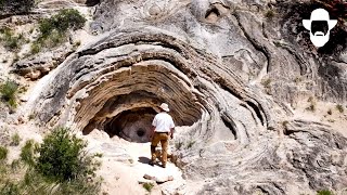
I think I would describe this outcrop as
wild. Wild in the way that the layers of
rock are contorted in every way
imaginable.
Wild in the internal structure of the
layers. There seems to be a vertical
fabric perpendicular to the bed
boundaries.
What kind of forces could deform rock
like this? Or is it some other process
creating these crazy patterns?
Hello, I'm Myron Cook. What an amazingly
wonderful place this is. As strange as
it can get. I mean, I I think this is
maybe the the most interesting strange
outcrop I've ever come up to.
And uh the first thing we want to know
is what's going on here? How are we
going to make sense of it? By the way,
the locals call this the greeneyed
monster. Now, that makes sense to me as
I look at it. And I want to say that
this is a remnant of Earth's healing
powers.
Now, that's a pretty provocative
statement for me to say that. Why would
I say this is a remnant of Earth's
healing powers? By the end of this
video, we'll know why. And it's it's
going to be a fun journey. You know, the
first thing we're going to do is make
some observations and build our
knowledge and and we'll we'll go on this
trip together and have some fun. The
first thing I want to do is take a
closer look at these layers of rock. The
layers are readily visible, but what
interests me is the fabric within these
layers. They have an orientation that's
perpendicular to the layer boundaries.
This is exactly the opposite of what we
would expect. This is a very rare
exception. I've only seen this phenomena
a handful of times. Normally, what we
would see is a fabric that's parallel to
the bedding boundaries or at a close
angle to the bedding boundaries. Another
thing I can do here is take some dilute
hydrochloric acid and put it on a sample
of this rock. Um, I don't think it's
going to show on video. You're going to
have to trust me on this one.
Uh, so I'm taking this dilute
hydrochloric acid. Oh, and it fizzes
like like crazy. For your old for you
old-timers, it fizzes like Alka-Seltzer
in water.
Fizzes to no end. I'll try it here on
camera. It's worth a try.
Oh, maybe it is showing up. It's such a
violent fizz. It is showing up.
Okay. Okay, well that's good. And what
this fizzing means is that it's calcium
carbonate. It's a great test for
limestone. If you put it on dolomite, it
just fizzes very little or maybe not at
all. But limestone, boy, it'll fizz like
this. And this is fizzing extra
vigorously because there's so much pore
space in the rock. It is completely full
of small holes and larger holes. Very
high paracity.
expanding our area of investigation.
There's something here right above this
outcrop I want to show you.
It appears to be some sort of collapse
feature.
From higher above, more of these
features come into view. Three large
holes are readily visible above our
interesting outcrop. Could they be
related?
Well, this is quite the hole in the
ground here. A sinkhole. That's what I
like to call it. Uh the cause of it is
yet to be determined.
Um it's made of limestone, kind of
thinly bedded, platey. It has ver some
of the similar textures as what we just
saw. So, it's definitely deposited in
the same basic way as far as this this
rim here.
and of and with the drone we saw there
are a couple others just nearby.
Looking more closely at the largest one
named the devil's punch bowl, we see
some classic features. Notice the wavy
bedding here and the vertical fabric in
this layer.
Here is a typical sample of the rock.
I'm thinking that these are somehow
connected to the outcrop we were just
looking at. So, as a young geologist
coming out and making these
observations, I would assume they're
connected until I'm proved otherwise by
other observations. So, we'll go we'll
work along with that assumption.
These rock outcrops on the other side of
the river catch my eye as well.
Here on the other side of the river, we
see similar features. We see some
layering. It's not as thick. Most of the
layers, individual layers aren't as
thick. We see the vertical texture here,
although it's more subtle. We don't see
as m much of the wavy, the dramatic,
crazy uh contortions in the bedding, but
we see local examples of it. Much of the
rock has this very distinctive look to
it. It is completely full of holes, very
porous.
It seems to be somewhat better
organized, but overall very similar. I
think it's it was deposited with by the
same processes.
Well, what do you think of this? It's
kind of a mound, a teepee, a small
volcano. Gosh, it could be about
anything, couldn't it? And the and that
fantastic outcrop is just right down
here past this tree here. So, could it
be related?
We have to assume at this point it is
related. And hopefully uh when you see
something like this, you're starting to
to formulate some thoughts and some
ideas as to what might be going on at
that wild outcrop.
The cone we just visited is here, but
notice there's another interesting
feature in this area.
The ridge along here is what catches my
eye. There's a lot to contemplate in
this one scene. We have the greeneyed
monster outcrop, the collapse features
above it, the curious limestone on the
other side of the river, the cone-shaped
feature, and there are many of those
scattered about, and the ridge. But
there are still more key observations we
need to make.
Let's look at an outcrop right in this
area.
I smile big when I see an outcrop like
this. A good friend of mine, a local
geologist by the name of Tom Anderson,
showed me this. I'm grateful he did.
Thank you, Tom. And I think many of you
have already figured some of the basics
of this out. We have a very steeply
dipping rock here at my back. It's near
vertical. And then right up against it
are nearly horizontal layers of rock.
This is a thinly bedded limestone and
has some of the characteristics we've
seen elsewhere in this strange
limestone.
And it just seems to be plastered up
against this. Very interesting. And
we're about a mile or so from the river.
There's a little drainage here that goes
on down towards the river that way. And
I think we need to investigate this
drainage just a bit more. Go upstream a
bit and see what we see, shall we?
Quite a beautiful place, isn't it? Boy,
I enjoy walking along here. And here,
right in front of me on this side of
this creek, there's a little branch of
it here, but on this drainage, I see
this um strange limestone welldeveloped.
And in fact, in the distance on the
other side, just over those flowers
there, you see a thin layer of it on the
other side. And you can't see it, but I
see it really well right over here as
well on the other side of this drainage.
It seems to be hugging the drainage.
This is interesting to think about,
isn't it? I was able to track the
limestone deposits along the drainage in
this area.
There are some interesting hills in the
area that catch my eye because from a
distance they appear to be capped by
limestone and limestone like this is out
of place. It doesn't fit the regional
geology. So clearly we need to
investigate it.
This one is named Till. Let's check it
out.
on top of Tea Hill, some 400 ft above
the river or so, as I walk along this on
top of this uh limestone,
I see this pattern here, which looks
very familiar with some of the other
patterns we've seen earlier down by the
river. So, this deposit seems quite
similar. We'll keep looking, but this
pattern is very distinctive. Nearby, we
see more interesting patterns on the
rock that are very distinctive.
What do you notice about this sequence
of gray rocks that sit on top of the red
formation?
It's resistant to erosion. It has a lot
of layers in it, and it looks like
limestone.
In fact, it is limestone.
It's very interesting to follow the
contact between the red formation
underneath and the limestone above.
It's an unconformity. And this informs
us that the red chug water formation
underwent erosion for a period and then
there was deposition of the limestone on
top.
What a pleasant hike coming here, hiking
up to the top of Tea Hill. And h yeah, I
like that. And I look at this limestone
here and I'll tell you, it's looking
kind of familiar to me. I'll show you
some photos here. Uh yeah, it's looking
familiar. Very familiar to what we saw
right down by the river.
And that's all interesting. We see the
the same features, the textural
features. We see layer upon layer upon
layer with these vertical lines within
it of this limestone.
So, it clearly was deposited in the same
way those layers were down down below
down by the river,
but we're 400 ft above the river. And
the way this sits on top of these red
beds here, this is oh 40t thick or more
here. Uh but the way it sits on top and
then we know that over there I know
uh over on top a round top over there I
won't hike up there. It has the same
material on top of it. And it turns out
there are plateaus scattered all about
this area with this material on top of
it. So, as we proceed forward with our
investigation, we're going to have to
figure out uh why it's here and how it
got here, which is a very fascinating
story. From above, we see the flat top
of Tea Hill and the river some 400 ft
below. The greeneyed monster outcrop is
here.
A quick comment. If you'd like to get an
insider view of how I create these
videos and learn a bit more about me,
you might check out the the link that I
put in the description of a video. It
turns out that Cowboy State Daily had a
film crew come out and follow me around.
It was fun.
And what are we to make of this big
mound behind me with the steep face here
on this side protruding out from the
hillside?
It kind of reminds me of that uh that
mound structure or tepee looking
structure we saw earlier. You have to
assume that they kind of have a similar
origin. And I think maybe these are the
clues that help us unravel all these
deposits of limestone, whether they be
down here by the river or way up on the
hills over here. Yeah, I think it's all
tied together. And of course, I've been
holding information back on you. I'm
kind of sly that way.
It turns out the very best evidence for
to to explain all this is right behind
the camera back here. Let me show you.
Look for features we saw in the ancient
outcrops we visited.
These deposits are made of a special
type of limestone called travertine
which forms in mineralrich hot springs
or in caves.
Terraces of various sizes are a common
feature of these deposits.
The source of the mineral hot springs
water is right here.
This artisian spring is about 40 ft
above the river. It flows at about 1,500
gall per minute at a temperature of 127°
F. The dissolved solids in the water is
about six times normal drinking water.
As the pressure drops and the water
cools, CO2 is released as gas bubbles.
This release of CO2 causes calcium
carbonate to precipitate out of solution
forming travertine.
Travertine is well known as a beautiful
building stone.
Rather amazing, isn't it? Just
astounding. And I think it's time to
reveal the location. I think that'd be
helpful. I'm in Thermopoulos, Wyoming.
Uh Thermopoulos, it turns out the
meaning of it in Greek is hot city. And
well, that makes sense, doesn't it? I
have so many memories here. We'd come to
the to the swimming areas, especially in
the winter with my kids and and enjoy
the cold, you know, the cold air and the
hot water. It's a great mix. Remember
one time I had a contest with my boys to
see who could roll around in the snow at
the edge of the springs or the pool area
the longest before they jumped in. Just
just great memories, lots of fun.
Once you see a modern system like this
and all the features and how what the
rock looks like and how it it kind of
lays in so to speak, it's quite easy to
identify it in the ancient record. And
we've seen ancient examples and that's
how geologists build their their
knowledge. They go out, they see modern
examples, then they go into the rock
record hiking around doing their mapping
and they stumble on some some travertine
that has similar features to this. they
know immediately what it's all about.
And that's kind of how that process
works. It's it's a lot of fun to be
involved in. Now, some of you may be
tempted to think, "Oh, this is really
cool now. I know. End of story. Let's
go." Well,
really, I think uh we've got about half
the story in. Uh we've got a lot of
answer uh questions to be answered. Uh
for instance,
where's all this hot water coming from?
What's the source of the heat? Is it
some magma chamber or something
underground?
Why is it artisian flowing up to the
surface even above the river? That's
quite unusual.
Uh what else? Um what other questions do
we Well, the source of the minerals, all
the mineral uh minerals in the water to
precipitate these massive amounts of
limestone throughout this whole area.
And I'm sure there's some other
questions that you're thinking about.
So, it's time to get into that and
figure out really why these springs are
here precisely and and how they how they
formed in the bigger picture. So, we've
still got some fun. Let's let's go on.
But first, I'd like to do a comparison
between the modern and ancient
travertine deposits. This area reminds
me of parts of the greeneyed monster
outcrop.
These features under the bridge also
remind me of the greeneyed outcrop.
This texture that we saw on the top of
Tea Hill certainly reminds me of the
modern deposits we see.
A wonderful example of modern travertine
deposition in Turkey. It's nearly
enveloped a Roman tomb. The patterns are
reminiscent of what we saw on Tea Hill.
Mammoth Hot Springs in Yellowstone
National Park has a wonderful example of
a recently abandoned cone. I think
Mammoth can help us understand the big
eye as well.
I think that the rounded forms that we
see in this area are just small versions
of the big eye. At one time, the Big Eye
had a nice smooth rounded front to it,
but it has since been eroded into
revealing the internal structure.
What do you think about the three sink
holes?
I think they're larger, rounder versions
of the current active big spring. Try to
imagine in each one of these holes a
beautiful pool of hot mineral-rich
waters pouring out over the edges and
building large travertine terraces.
Finally, I hope you noticed the origin
of this vertically oriented fibrous
travertine that we've seen everywhere.
It's pretty clear on the front edge of
this travertine terrace. This isn't the
only way this fibrous uh travertine
forms, but it's probably the most
common.
A wonderful thing about the Hot Springs
State Park is that there's a herd of
buffalo roaming about.
Now, right behind me is a really
important clue as to why we have these
thermal hot springs. We have these
steeply dipping layers of rock. Huh. You
know, that's not so unusual. We've seen
a lot of steeply dipping rock.
But you know the mountains off in the
distance, they have a gentle dip in the
opposite direction. They're coming
together. These very steeply dipping and
the mountains very gently dipping,
coming together, coming together. So the
layers from the mountain go deep
underground and now they seem to come
back up here. I think that's an
important clue. Steeply dipping rocks
near to the springs. Why is that so
important? Here is a nice perspective of
the tilted rock layers.
The springs are located here and we see
the steeply dipping rock layers in this
area. Notice off in the distance the
gentle slopes of the mountains.
Looking more closely at the mountain, we
see the hints of a canyon cut into it.
It's the spectacular Wind River Canyon
that the Big Horn River has cut.
We clearly see great formations of rock
dipping down into the ground towards
Thermopoulos.
Looking in the other direction up river,
we see that there are many formations of
rock that are dipping in this manner.
To the whiteboard we go. Now, this is a
rather strange drawing. It is a
cross-sectional view. So, let me uh put
a tree here. I'll put it right here.
Here we go. Looking sideways into the
earth. A cut into the earth. Uh, and I
have this gigantic hose. So, imagine
that. A gigantic garden hose that's from
above ground comes down underneath the
earth, comes back up to here. And at
this end, the we'll restrict the size of
the hose. I can't really show that here,
but we'll make it much smaller. And over
here, I have this giant funnel. I'm
pouring water in. And you know what's
going to happen? It's going to start
building the water level up because it
can't escape fast enough out here. So
the water level here might build up.
We'll say right here in this case. So
somewhere about in there we have our
water level which means there's pressure
at this end. So yeah, water is going to
come out kind of like a fountain. And
here we have an artisian spring. And I
think this is a a simple way to envision
how this artisian water can happen. But
now we need to look at the real world,
the geology world, a more realistic
sketch of nature out here and the
geology that we're dealing with.
Although it's simplified obviously,
still it is a cross-sectional view. So
I've drawn my little tree here and this
is ground level. Going along here, right
here would be the thermoploolis hot
springs area. We go along. We rise up up
on the side of the mountain and we have
all these gently dipping layers of rock
on the side of the mountain coming down
underground towards Thermopoulos. Now
here we have this fold. Uh I've got this
dashed line to show that this layer for
instance used to come up and over the
fold but got eroded down to the ground
level here. Uh the blue layer is the
permeable layer. That's the aquifer that
has the water in it. And of course, we
don't have uh big hoses or things, but
we do have layers of rock that can get
confined in certain situations. And what
is that? Well, here I have a layer of
shale underneath it that acts as quote
the rubber of the hose and a layer of
shale above it to confine it. And the
rainwater is coming down up on the
mountain and it's infiltrating this
layer of rock and building up. It's just
that's where the water enters, but it's
having troubles escaping out here and it
builds up pressure.
I'm sure many of you are ahead of me now
on this whole story and you're thinking
about this fold and what might happen
here and how it affects the aquifer. And
indeed, yes. This fold of course where
you bend this rock you have faults and
fractures and they go deep into the
ground and they're going to intersect
this aquifer and they provide conduits
for fluid to escape this overpressured
fluid and and rise up to the surface.
And there we have our hot springs. Using
Google Earth, let's take a look at the
fold that I mentioned on the whiteboard.
It's referred to as the thermoplas
anacline and this is the western end of
it. The blue dashed lines show how just
one of many layers at one time went up
and over the fold and have subsequently
been eroded. The hot springs and the
community of Thermopoulos are way down
here. So this is a large fold and we'll
continue to follow it. In this area, the
anacline isn't easily visible, but as we
continue along, it will become more
visible again.
The hot springs are right here.
A great view of Roundtop, Tea Hill, and
Monument Hill, all capped with
travertine.
Looking down on Tea Hill, we see
Monument Hill in the background, as well
as the active area of travertine
deposition. The eroded anacline is
clearly in view. I've put a white dashed
line on one of the layers to show what
has been eroded. It's not surprising
that there are many fractures and faults
at the crest of this anacline providing
conduits for this hot mineral water to
rise to the surface. The main aquifer is
about 2,000 ft underground. With our
understanding of overpressured water, we
can now make sense of some of the
features we've observed. Tepee Spring.
Really an interesting feature.
beautiful.
Well, it turns out it's man-made, but
the processes are similar. They have
taken water from the big spring, this uh
mineral laden water, pump it out a pipe
at the top, let it cascade down, and
start to build this cone. And we've seen
some cones not too uh uh different than
this where nature has because of the
overpressured water coming up, bubbling
up, building up cones uh scattered
about. As I recall, there are like 40
cones that have been identified
throughout this area, all ancient. Uh
there is no modern cone that I can think
of over out here. So very interesting
indeed.
Water is only pumped during the spring
and summer months, and this has built up
since 1906.
Amazing.
Mineral water coming up along a fracture
or fault formed this ridge we observed.
It's pretty impressive to think that the
water came up some 2,000 ft along this
fracture or fault.
But what about the source of the
minerals to precipitate so much
travertine? And what's the heat source?
Let's go up the river about halfway
through the Wind River Canyon. Here we
see about 800 feet of Mississippian age
or about 350 millionyear-old limestone.
This is the main aquifer and when
slightly acidic rainwater percolates
into it, dissolution of the limestone
occurs, which of course is
reprecipitated at the hot springs.
One might would think that there's a hot
molten magma body under the ground
providing the heat for this water. But
it's a simpler story. At its deepest
point, the aquifer is about 6,000 ft
underground. And due to the natural
thermal gradient of the Earth, it sits
at about 160°. And of course, the water
does too. As the water slowly rises from
the depths to the springs, it cools off
to the 127° flowing temperature.
Hopefully, you've noticed that the vast
majority of the travertine deposits are
not too far above the river, and they're
also quite close to it. Do you have
thoughts as to why that would be the
case?
To help explain this, of course, we turn
to the trusty old whiteboard. And I've
gotten a bit fancy here. I've tried to
draw a 3D block diagram. So this face
here would be a cut down into the earth
as well as this side over here. And this
top surface with the trees on it, I want
it to be flat here depicted as flat. Uh
this layer is the aquifer and it's been
cut by a fault. In this case, a reverse
fault. It could be a normal fault or it
could be just fractures.
And if the fault is homogeneous in in
our imaginary world anyway, it could
flow the water would flow at a similar
rate all along the ground surface along
this vault.
A simple thought experiment for us to
think about. Let's imagine if we had
some massive earthmoving equipment and
we decided to come out here and dig a
great big deep giant hole along the
fault out here and just start digging
down. Well, if you think about what
would happen, it wouldn't take too long
to where all the water would want to
leak in that hole cuz we're getting
closer to the aquifer. Less pressure is
needed to bring that water up to to the
bottom of that hole. So, it all wants to
go in that deep hole. Well, if you think
about it, rivers actually are kind of
the same thing, aren't they? They they
are cutting holes or not really holes,
canyons across these faults and
fractures, and they become the low spot.
And that's where the vast majority uh of
the springs want to come up is right
near the river bottom. In fact, people
have seen or do see uh hot springs in
the bottom of the river. Armed with this
knowledge, I think we can better
understand the amazing unconformity we
visited earlier. A cross-sectional view
of this gully or draw that we find so
interesting, at least I do, with this
cool unconformity. So, we start with it
cutting down into these steeply dipping
rocks. In fact, on one side, we have
this layer here that's of limestone
that's really quite steep.
And as it cuts down, it happens to
intersect a a fracture or fault that's
tied into the aquifer, this
overpressured hot water, and and it
springs up along the bottom of this
draw. And now, instead of erosion
occurring, deposition occurs of this
travertine, and it starts to fill in.
through time it fills in in some areas
some pretty thick deposits of travertine
and then as it seems to happen all over
in this area the the spring dies out
moves to a different place it gets
plugged up with travertine or something
and erosion starts to occur again. So,
here we go with erosion. And it cuts
down.
It's cutting out most of the travertine
deposits and continues to cut deeper
down here. And we have a new wash with
remnants of this travertine along the
sides of the wash, creating this
wonderful angular unconformity.
This all seems to make good sense, but
we have an issue here. We've noticed
several hills high above the river
capped with travertine. How could this
possibly be?
I think Wind River Canyon provides us
the answer. Let's think about time and
what the river might have looked like
millions of years ago.
The Big Horn River, also known as the
Wind River on the south side of the
canyon, is steadily cutting deeper into
the earth. And we know that this has
been the case for a very long time. In
fact, it has cut this entire canyon.
This simple deduction informs us that in
the past the bottom of the river was
higher, much higher. Returning to the
travertine capped hills, we can deduce
that the bottom of the river was near to
these travertine deposits. Travertine is
more resistant to erosion than the
underlying red beds. Therefore,
everything around it eroded more
quickly, leaving the hills that we
observe today. The various levels of
travertine deposits document the down
cutting history of the Big Horn River.
That's just really fun to think about.
At the beginning of this video, I
mentioned that this is a remnant of
Earth's healing powers. For thousands of
years, natives came to these springs
seeking these powers. This tradition has
continued on to modern times as people
from far and wide come to enjoy their
many benefits.
The geology informs us that these
healing waters should be present in the
distant future for people to enjoy.
What a wonderful adventure we've been on
together, haven't we? Uh making these
observations, putting it all together,
and learning about hot springs, mineral
hot springs, and and travertine
development and all that fun stuff. But
there's more to do here in Thermopoulos.
There's some great fishing. Uh you have
the Wind River Canyon, super cool
geology there. You have the thermal
springs that we've been talking about,
of course, and you have a great dinosaur
museum to boot. So come on and check it
out. And I hope you've enjoyed watching
this video as much as I've enjoyed
making it. Thank you for watching.
Full transcript without timestamps
I think I would describe this outcrop as wild. Wild in the way that the layers of rock are contorted in every way imaginable. Wild in the internal structure of the layers. There seems to be a vertical fabric perpendicular to the bed boundaries. What kind of forces could deform rock like this? Or is it some other process creating these crazy patterns? Hello, I'm Myron Cook. What an amazingly wonderful place this is. As strange as it can get. I mean, I I think this is maybe the the most interesting strange outcrop I've ever come up to. And uh the first thing we want to know is what's going on here? How are we going to make sense of it? By the way, the locals call this the greeneyed monster. Now, that makes sense to me as I look at it. And I want to say that this is a remnant of Earth's healing powers. Now, that's a pretty provocative statement for me to say that. Why would I say this is a remnant of Earth's healing powers? By the end of this video, we'll know why. And it's it's going to be a fun journey. You know, the first thing we're going to do is make some observations and build our knowledge and and we'll we'll go on this trip together and have some fun. The first thing I want to do is take a closer look at these layers of rock. The layers are readily visible, but what interests me is the fabric within these layers. They have an orientation that's perpendicular to the layer boundaries. This is exactly the opposite of what we would expect. This is a very rare exception. I've only seen this phenomena a handful of times. Normally, what we would see is a fabric that's parallel to the bedding boundaries or at a close angle to the bedding boundaries. Another thing I can do here is take some dilute hydrochloric acid and put it on a sample of this rock. Um, I don't think it's going to show on video. You're going to have to trust me on this one. Uh, so I'm taking this dilute hydrochloric acid. Oh, and it fizzes like like crazy. For your old for you old-timers, it fizzes like Alka-Seltzer in water. Fizzes to no end. I'll try it here on camera. It's worth a try. Oh, maybe it is showing up. It's such a violent fizz. It is showing up. Okay. Okay, well that's good. And what this fizzing means is that it's calcium carbonate. It's a great test for limestone. If you put it on dolomite, it just fizzes very little or maybe not at all. But limestone, boy, it'll fizz like this. And this is fizzing extra vigorously because there's so much pore space in the rock. It is completely full of small holes and larger holes. Very high paracity. expanding our area of investigation. There's something here right above this outcrop I want to show you. It appears to be some sort of collapse feature. From higher above, more of these features come into view. Three large holes are readily visible above our interesting outcrop. Could they be related? Well, this is quite the hole in the ground here. A sinkhole. That's what I like to call it. Uh the cause of it is yet to be determined. Um it's made of limestone, kind of thinly bedded, platey. It has ver some of the similar textures as what we just saw. So, it's definitely deposited in the same basic way as far as this this rim here. and of and with the drone we saw there are a couple others just nearby. Looking more closely at the largest one named the devil's punch bowl, we see some classic features. Notice the wavy bedding here and the vertical fabric in this layer. Here is a typical sample of the rock. I'm thinking that these are somehow connected to the outcrop we were just looking at. So, as a young geologist coming out and making these observations, I would assume they're connected until I'm proved otherwise by other observations. So, we'll go we'll work along with that assumption. These rock outcrops on the other side of the river catch my eye as well. Here on the other side of the river, we see similar features. We see some layering. It's not as thick. Most of the layers, individual layers aren't as thick. We see the vertical texture here, although it's more subtle. We don't see as m much of the wavy, the dramatic, crazy uh contortions in the bedding, but we see local examples of it. Much of the rock has this very distinctive look to it. It is completely full of holes, very porous. It seems to be somewhat better organized, but overall very similar. I think it's it was deposited with by the same processes. Well, what do you think of this? It's kind of a mound, a teepee, a small volcano. Gosh, it could be about anything, couldn't it? And the and that fantastic outcrop is just right down here past this tree here. So, could it be related? We have to assume at this point it is related. And hopefully uh when you see something like this, you're starting to to formulate some thoughts and some ideas as to what might be going on at that wild outcrop. The cone we just visited is here, but notice there's another interesting feature in this area. The ridge along here is what catches my eye. There's a lot to contemplate in this one scene. We have the greeneyed monster outcrop, the collapse features above it, the curious limestone on the other side of the river, the cone-shaped feature, and there are many of those scattered about, and the ridge. But there are still more key observations we need to make. Let's look at an outcrop right in this area. I smile big when I see an outcrop like this. A good friend of mine, a local geologist by the name of Tom Anderson, showed me this. I'm grateful he did. Thank you, Tom. And I think many of you have already figured some of the basics of this out. We have a very steeply dipping rock here at my back. It's near vertical. And then right up against it are nearly horizontal layers of rock. This is a thinly bedded limestone and has some of the characteristics we've seen elsewhere in this strange limestone. And it just seems to be plastered up against this. Very interesting. And we're about a mile or so from the river. There's a little drainage here that goes on down towards the river that way. And I think we need to investigate this drainage just a bit more. Go upstream a bit and see what we see, shall we? Quite a beautiful place, isn't it? Boy, I enjoy walking along here. And here, right in front of me on this side of this creek, there's a little branch of it here, but on this drainage, I see this um strange limestone welldeveloped. And in fact, in the distance on the other side, just over those flowers there, you see a thin layer of it on the other side. And you can't see it, but I see it really well right over here as well on the other side of this drainage. It seems to be hugging the drainage. This is interesting to think about, isn't it? I was able to track the limestone deposits along the drainage in this area. There are some interesting hills in the area that catch my eye because from a distance they appear to be capped by limestone and limestone like this is out of place. It doesn't fit the regional geology. So clearly we need to investigate it. This one is named Till. Let's check it out. on top of Tea Hill, some 400 ft above the river or so, as I walk along this on top of this uh limestone, I see this pattern here, which looks very familiar with some of the other patterns we've seen earlier down by the river. So, this deposit seems quite similar. We'll keep looking, but this pattern is very distinctive. Nearby, we see more interesting patterns on the rock that are very distinctive. What do you notice about this sequence of gray rocks that sit on top of the red formation? It's resistant to erosion. It has a lot of layers in it, and it looks like limestone. In fact, it is limestone. It's very interesting to follow the contact between the red formation underneath and the limestone above. It's an unconformity. And this informs us that the red chug water formation underwent erosion for a period and then there was deposition of the limestone on top. What a pleasant hike coming here, hiking up to the top of Tea Hill. And h yeah, I like that. And I look at this limestone here and I'll tell you, it's looking kind of familiar to me. I'll show you some photos here. Uh yeah, it's looking familiar. Very familiar to what we saw right down by the river. And that's all interesting. We see the the same features, the textural features. We see layer upon layer upon layer with these vertical lines within it of this limestone. So, it clearly was deposited in the same way those layers were down down below down by the river, but we're 400 ft above the river. And the way this sits on top of these red beds here, this is oh 40t thick or more here. Uh but the way it sits on top and then we know that over there I know uh over on top a round top over there I won't hike up there. It has the same material on top of it. And it turns out there are plateaus scattered all about this area with this material on top of it. So, as we proceed forward with our investigation, we're going to have to figure out uh why it's here and how it got here, which is a very fascinating story. From above, we see the flat top of Tea Hill and the river some 400 ft below. The greeneyed monster outcrop is here. A quick comment. If you'd like to get an insider view of how I create these videos and learn a bit more about me, you might check out the the link that I put in the description of a video. It turns out that Cowboy State Daily had a film crew come out and follow me around. It was fun. And what are we to make of this big mound behind me with the steep face here on this side protruding out from the hillside? It kind of reminds me of that uh that mound structure or tepee looking structure we saw earlier. You have to assume that they kind of have a similar origin. And I think maybe these are the clues that help us unravel all these deposits of limestone, whether they be down here by the river or way up on the hills over here. Yeah, I think it's all tied together. And of course, I've been holding information back on you. I'm kind of sly that way. It turns out the very best evidence for to to explain all this is right behind the camera back here. Let me show you. Look for features we saw in the ancient outcrops we visited. These deposits are made of a special type of limestone called travertine which forms in mineralrich hot springs or in caves. Terraces of various sizes are a common feature of these deposits. The source of the mineral hot springs water is right here. This artisian spring is about 40 ft above the river. It flows at about 1,500 gall per minute at a temperature of 127° F. The dissolved solids in the water is about six times normal drinking water. As the pressure drops and the water cools, CO2 is released as gas bubbles. This release of CO2 causes calcium carbonate to precipitate out of solution forming travertine. Travertine is well known as a beautiful building stone. Rather amazing, isn't it? Just astounding. And I think it's time to reveal the location. I think that'd be helpful. I'm in Thermopoulos, Wyoming. Uh Thermopoulos, it turns out the meaning of it in Greek is hot city. And well, that makes sense, doesn't it? I have so many memories here. We'd come to the to the swimming areas, especially in the winter with my kids and and enjoy the cold, you know, the cold air and the hot water. It's a great mix. Remember one time I had a contest with my boys to see who could roll around in the snow at the edge of the springs or the pool area the longest before they jumped in. Just just great memories, lots of fun. Once you see a modern system like this and all the features and how what the rock looks like and how it it kind of lays in so to speak, it's quite easy to identify it in the ancient record. And we've seen ancient examples and that's how geologists build their their knowledge. They go out, they see modern examples, then they go into the rock record hiking around doing their mapping and they stumble on some some travertine that has similar features to this. they know immediately what it's all about. And that's kind of how that process works. It's it's a lot of fun to be involved in. Now, some of you may be tempted to think, "Oh, this is really cool now. I know. End of story. Let's go." Well, really, I think uh we've got about half the story in. Uh we've got a lot of answer uh questions to be answered. Uh for instance, where's all this hot water coming from? What's the source of the heat? Is it some magma chamber or something underground? Why is it artisian flowing up to the surface even above the river? That's quite unusual. Uh what else? Um what other questions do we Well, the source of the minerals, all the mineral uh minerals in the water to precipitate these massive amounts of limestone throughout this whole area. And I'm sure there's some other questions that you're thinking about. So, it's time to get into that and figure out really why these springs are here precisely and and how they how they formed in the bigger picture. So, we've still got some fun. Let's let's go on. But first, I'd like to do a comparison between the modern and ancient travertine deposits. This area reminds me of parts of the greeneyed monster outcrop. These features under the bridge also remind me of the greeneyed outcrop. This texture that we saw on the top of Tea Hill certainly reminds me of the modern deposits we see. A wonderful example of modern travertine deposition in Turkey. It's nearly enveloped a Roman tomb. The patterns are reminiscent of what we saw on Tea Hill. Mammoth Hot Springs in Yellowstone National Park has a wonderful example of a recently abandoned cone. I think Mammoth can help us understand the big eye as well. I think that the rounded forms that we see in this area are just small versions of the big eye. At one time, the Big Eye had a nice smooth rounded front to it, but it has since been eroded into revealing the internal structure. What do you think about the three sink holes? I think they're larger, rounder versions of the current active big spring. Try to imagine in each one of these holes a beautiful pool of hot mineral-rich waters pouring out over the edges and building large travertine terraces. Finally, I hope you noticed the origin of this vertically oriented fibrous travertine that we've seen everywhere. It's pretty clear on the front edge of this travertine terrace. This isn't the only way this fibrous uh travertine forms, but it's probably the most common. A wonderful thing about the Hot Springs State Park is that there's a herd of buffalo roaming about. Now, right behind me is a really important clue as to why we have these thermal hot springs. We have these steeply dipping layers of rock. Huh. You know, that's not so unusual. We've seen a lot of steeply dipping rock. But you know the mountains off in the distance, they have a gentle dip in the opposite direction. They're coming together. These very steeply dipping and the mountains very gently dipping, coming together, coming together. So the layers from the mountain go deep underground and now they seem to come back up here. I think that's an important clue. Steeply dipping rocks near to the springs. Why is that so important? Here is a nice perspective of the tilted rock layers. The springs are located here and we see the steeply dipping rock layers in this area. Notice off in the distance the gentle slopes of the mountains. Looking more closely at the mountain, we see the hints of a canyon cut into it. It's the spectacular Wind River Canyon that the Big Horn River has cut. We clearly see great formations of rock dipping down into the ground towards Thermopoulos. Looking in the other direction up river, we see that there are many formations of rock that are dipping in this manner. To the whiteboard we go. Now, this is a rather strange drawing. It is a cross-sectional view. So, let me uh put a tree here. I'll put it right here. Here we go. Looking sideways into the earth. A cut into the earth. Uh, and I have this gigantic hose. So, imagine that. A gigantic garden hose that's from above ground comes down underneath the earth, comes back up to here. And at this end, the we'll restrict the size of the hose. I can't really show that here, but we'll make it much smaller. And over here, I have this giant funnel. I'm pouring water in. And you know what's going to happen? It's going to start building the water level up because it can't escape fast enough out here. So the water level here might build up. We'll say right here in this case. So somewhere about in there we have our water level which means there's pressure at this end. So yeah, water is going to come out kind of like a fountain. And here we have an artisian spring. And I think this is a a simple way to envision how this artisian water can happen. But now we need to look at the real world, the geology world, a more realistic sketch of nature out here and the geology that we're dealing with. Although it's simplified obviously, still it is a cross-sectional view. So I've drawn my little tree here and this is ground level. Going along here, right here would be the thermoploolis hot springs area. We go along. We rise up up on the side of the mountain and we have all these gently dipping layers of rock on the side of the mountain coming down underground towards Thermopoulos. Now here we have this fold. Uh I've got this dashed line to show that this layer for instance used to come up and over the fold but got eroded down to the ground level here. Uh the blue layer is the permeable layer. That's the aquifer that has the water in it. And of course, we don't have uh big hoses or things, but we do have layers of rock that can get confined in certain situations. And what is that? Well, here I have a layer of shale underneath it that acts as quote the rubber of the hose and a layer of shale above it to confine it. And the rainwater is coming down up on the mountain and it's infiltrating this layer of rock and building up. It's just that's where the water enters, but it's having troubles escaping out here and it builds up pressure. I'm sure many of you are ahead of me now on this whole story and you're thinking about this fold and what might happen here and how it affects the aquifer. And indeed, yes. This fold of course where you bend this rock you have faults and fractures and they go deep into the ground and they're going to intersect this aquifer and they provide conduits for fluid to escape this overpressured fluid and and rise up to the surface. And there we have our hot springs. Using Google Earth, let's take a look at the fold that I mentioned on the whiteboard. It's referred to as the thermoplas anacline and this is the western end of it. The blue dashed lines show how just one of many layers at one time went up and over the fold and have subsequently been eroded. The hot springs and the community of Thermopoulos are way down here. So this is a large fold and we'll continue to follow it. In this area, the anacline isn't easily visible, but as we continue along, it will become more visible again. The hot springs are right here. A great view of Roundtop, Tea Hill, and Monument Hill, all capped with travertine. Looking down on Tea Hill, we see Monument Hill in the background, as well as the active area of travertine deposition. The eroded anacline is clearly in view. I've put a white dashed line on one of the layers to show what has been eroded. It's not surprising that there are many fractures and faults at the crest of this anacline providing conduits for this hot mineral water to rise to the surface. The main aquifer is about 2,000 ft underground. With our understanding of overpressured water, we can now make sense of some of the features we've observed. Tepee Spring. Really an interesting feature. beautiful. Well, it turns out it's man-made, but the processes are similar. They have taken water from the big spring, this uh mineral laden water, pump it out a pipe at the top, let it cascade down, and start to build this cone. And we've seen some cones not too uh uh different than this where nature has because of the overpressured water coming up, bubbling up, building up cones uh scattered about. As I recall, there are like 40 cones that have been identified throughout this area, all ancient. Uh there is no modern cone that I can think of over out here. So very interesting indeed. Water is only pumped during the spring and summer months, and this has built up since 1906. Amazing. Mineral water coming up along a fracture or fault formed this ridge we observed. It's pretty impressive to think that the water came up some 2,000 ft along this fracture or fault. But what about the source of the minerals to precipitate so much travertine? And what's the heat source? Let's go up the river about halfway through the Wind River Canyon. Here we see about 800 feet of Mississippian age or about 350 millionyear-old limestone. This is the main aquifer and when slightly acidic rainwater percolates into it, dissolution of the limestone occurs, which of course is reprecipitated at the hot springs. One might would think that there's a hot molten magma body under the ground providing the heat for this water. But it's a simpler story. At its deepest point, the aquifer is about 6,000 ft underground. And due to the natural thermal gradient of the Earth, it sits at about 160°. And of course, the water does too. As the water slowly rises from the depths to the springs, it cools off to the 127° flowing temperature. Hopefully, you've noticed that the vast majority of the travertine deposits are not too far above the river, and they're also quite close to it. Do you have thoughts as to why that would be the case? To help explain this, of course, we turn to the trusty old whiteboard. And I've gotten a bit fancy here. I've tried to draw a 3D block diagram. So this face here would be a cut down into the earth as well as this side over here. And this top surface with the trees on it, I want it to be flat here depicted as flat. Uh this layer is the aquifer and it's been cut by a fault. In this case, a reverse fault. It could be a normal fault or it could be just fractures. And if the fault is homogeneous in in our imaginary world anyway, it could flow the water would flow at a similar rate all along the ground surface along this vault. A simple thought experiment for us to think about. Let's imagine if we had some massive earthmoving equipment and we decided to come out here and dig a great big deep giant hole along the fault out here and just start digging down. Well, if you think about what would happen, it wouldn't take too long to where all the water would want to leak in that hole cuz we're getting closer to the aquifer. Less pressure is needed to bring that water up to to the bottom of that hole. So, it all wants to go in that deep hole. Well, if you think about it, rivers actually are kind of the same thing, aren't they? They they are cutting holes or not really holes, canyons across these faults and fractures, and they become the low spot. And that's where the vast majority uh of the springs want to come up is right near the river bottom. In fact, people have seen or do see uh hot springs in the bottom of the river. Armed with this knowledge, I think we can better understand the amazing unconformity we visited earlier. A cross-sectional view of this gully or draw that we find so interesting, at least I do, with this cool unconformity. So, we start with it cutting down into these steeply dipping rocks. In fact, on one side, we have this layer here that's of limestone that's really quite steep. And as it cuts down, it happens to intersect a a fracture or fault that's tied into the aquifer, this overpressured hot water, and and it springs up along the bottom of this draw. And now, instead of erosion occurring, deposition occurs of this travertine, and it starts to fill in. through time it fills in in some areas some pretty thick deposits of travertine and then as it seems to happen all over in this area the the spring dies out moves to a different place it gets plugged up with travertine or something and erosion starts to occur again. So, here we go with erosion. And it cuts down. It's cutting out most of the travertine deposits and continues to cut deeper down here. And we have a new wash with remnants of this travertine along the sides of the wash, creating this wonderful angular unconformity. This all seems to make good sense, but we have an issue here. We've noticed several hills high above the river capped with travertine. How could this possibly be? I think Wind River Canyon provides us the answer. Let's think about time and what the river might have looked like millions of years ago. The Big Horn River, also known as the Wind River on the south side of the canyon, is steadily cutting deeper into the earth. And we know that this has been the case for a very long time. In fact, it has cut this entire canyon. This simple deduction informs us that in the past the bottom of the river was higher, much higher. Returning to the travertine capped hills, we can deduce that the bottom of the river was near to these travertine deposits. Travertine is more resistant to erosion than the underlying red beds. Therefore, everything around it eroded more quickly, leaving the hills that we observe today. The various levels of travertine deposits document the down cutting history of the Big Horn River. That's just really fun to think about. At the beginning of this video, I mentioned that this is a remnant of Earth's healing powers. For thousands of years, natives came to these springs seeking these powers. This tradition has continued on to modern times as people from far and wide come to enjoy their many benefits. The geology informs us that these healing waters should be present in the distant future for people to enjoy. What a wonderful adventure we've been on together, haven't we? Uh making these observations, putting it all together, and learning about hot springs, mineral hot springs, and and travertine development and all that fun stuff. But there's more to do here in Thermopoulos. There's some great fishing. Uh you have the Wind River Canyon, super cool geology there. You have the thermal springs that we've been talking about, of course, and you have a great dinosaur museum to boot. So come on and check it out. And I hope you've enjoyed watching this video as much as I've enjoyed making it. Thank you for watching.
Download Subtitles
These subtitles were extracted using the Free YouTube Subtitle Downloader by LunaNotes.
Download more subtitlesRelated Videos

Download Subtitles for 'You Won't Expect This...' Video
Enhance your viewing experience by downloading accurate subtitles for the video 'You Won't Expect This...'. Perfect for better understanding, accessibility, and enjoying the content without missing any details.

Download Subtitles for Your Favorite Videos Easily
Enhance your video watching experience by downloading accurate subtitles and captions. Enjoy better understanding, accessibility, and language support for all your favorite videos.

Download Accurate Subtitles and Captions for Your Videos
Easily download high-quality subtitles to enhance your video viewing experience. Subtitles improve comprehension, accessibility, and engagement for diverse audiences. Get captions quickly for better understanding and enjoyment of any video content.

Download Subtitles and Captions for Any Video Easily
Enhance your viewing experience by downloading accurate subtitles and captions for any video. Improve comprehension, accessibility, and enjoy content in multiple languages effortlessly with our easy-to-use subtitle downloader.

Download Subtitles for How to Reset Your Entire Life Video
Get accurate and easy-to-read subtitles for the video 'How to Reset Your Entire Life by Doing Nothing.' Enhance your understanding, follow along effortlessly, and enjoy a better viewing experience with downloadable captions.
Most Viewed

Untertitel für 'Nicos Weg' Deutsch lernen A1 Film herunterladen
Laden Sie die Untertitel für den gesamten Film 'Nicos Weg' herunter, um Ihr Deutschlernen auf A1 Niveau zu unterstützen. Untertitel helfen Ihnen, Wortschatz und Aussprache besser zu verstehen und verbessern das Hörverständnis effektiv.

ดาวน์โหลดซับไตเติ้ล DMD LAND 3 The Final Land Day 1
ดาวน์โหลดซับไตเติ้ลสำหรับวิดีโอ DMD LAND 3 The Final Land Day 1 เพื่อช่วยให้เข้าใจเนื้อหาได้ง่ายขึ้น และเพิ่มความสะดวกในการติดตามทุกช่วงเวลา เหมาะสำหรับผู้ชมที่ต้องการความชัดเจนและเข้าถึงข้อมูลอย่างครบถ้วน

Descarga Subtítulos para NARCISISMO | 6 DE COPAS - Episodio 63
Accede fácilmente a los subtítulos del episodio 63 de '6 DE COPAS', centrado en el narcisismo. Descargar estos subtítulos te ayudará a entender mejor el contenido y mejorar la experiencia de visualización.

Subtítulos para TIPOS DE APEGO | 6 DE COPAS Episodio 56
Descarga los subtítulos para el episodio 56 de la tercera temporada de 6 DE COPAS, centrado en los tipos de apego. Mejora tu comprensión y disfruta del contenido en detalle con nuestros subtítulos precisos y accesibles.
Download Subtitles for Your Favorite Videos Easily
Enhance your video watching experience by downloading accurate subtitles and captions. Enjoy better understanding, accessibility, and language support for all your favorite videos.

If you found these subtitles useful, consider buying us a coffee. It would help us a lot!